Monday, July 18

Hampta Pass and Chandratal Trek Log

I was exploring some extended weekend treks as my office colleagues also wanted to come along on my next trek. After searching and negotiating a lot, no agreeable trek couldn't be decided and now that I have to travel solo, I finally decided to go for Hampta Pass and Chandratal.. Hampta pass trek starts from Manali, Himachal Pradesh. It is a small pass on Pir Panjal range of Himalayas, between Lahaul and Kullu valley in Himachal Pradesh. Vertical rock walls, water falls, hanging glaciers, tiny lakes, peaks rising above 6000 m are main characteristics of this trek. I was very excited about this trek because I was finally getting another chance to see Chandratal.


Kiran was also in town and ready for a weekend trek. We left Delhi on Thursday, 14 July so that we had an extra day before next week starts. Bus to Manali was running late and we reached there around 11A.M. After having heavy dinner around noon, we took a cab for Jobra. It takes an hour and forty hairpin bends to arrive at Jobra. It was around 2 PM when we reached there. We left immediately, as we had planned to reach Balu Ka Ghera on our first day of trek and it was already late. It had rained earlier in the day and path was slippery till Chika village.


In few hours of trek, crossing few streams we reached Jwara. Clouds were all around us and visibility was very poor.

Balu ka ghera was still like an hour far from Jwara. There wasn't much daylight left and it could rain anytime. We decided to pitch our tents in Jwara. In the backdrop, we had a vertical rocky cliff with a nice view of waterfall. There was a shop in Jwara from where we got ourselves nice dinner for the night.


Campsite at Jwara


It was Saturday, June 16th. We started for Balu ka Ghera early morning next day. it was all misty from the beginning which was giving the whole valley a mystic look.

It started raining heavily when we reached Balu Ka Ghera. We got 4 parathas packed from there to have lunch later in the day. After more than an hour wait in Balu Ka Ghera, when the rain didn't stop; we prepared ourselves to walk in rain.

There was a Dutch couple, whom we had met in Jwara. They also arrived Balu Ka Ghera when we were about to leave. We started from Balu Ka Ghera together. They were thinking of returning back from the pass but we had plans to go further. Before the ascent to pass starts, there is a big lake where we bid them goodbye and continued our journey.
Small lake on the way up to pass

In heavy rain, the stream beside us was ferocious which actually accompanied us all along the trek in the valley. After crossing the some boulders, we reached the glacier. In such low visibility, it was getting difficult to find our way forward. Kiran was incessantly asking whether we are on the right path or not. I followed the tracks of mules on the glacier and reached the plateau. It was real cloudy and it seemed that I had lost my way here. We had a pack biscuit there and decided to look closely for tracks. It seemed, that we had to go back and follow the track more closely. On our left was a vertical rocky cliff.
The valley, clouds ahead on the pass

It was there when I heard some sound of mules walking somewhere nearby. I rushed towards the noise, though between so dense clouds, it was being difficult to figure out. Following the mule sound, I heard voice of a man controlling the mules. We shouted and asked whether anybody is there. The mules were gone and lost in the clouds by then. After few minutes, someone replied to our hello. When we rushed towards the sound, it was the same dutch couple with their guide. The lady told me, that they decided to cross the pass same day. The lady was was kind enough to offer us chocolates. We were just few meters away from the trail, but without their help we definitely would've gone in the wrong direction. This could've lost us at least few precious hours. We were actually few meters away from the trail. It's just that the trail makes an unusual bend towards left while going up at the highest point of trek which we would have easily figured out in clearer sky.

Towards Shiagoru From Hampta Pass
With them, we started our descent to Shiagoru. It's a steep descent which was little slippery due to rains. The rain was little slow at this part of valley (Lahaul). If it was a normal day, we could've had a nice view of Indrasan peak which was right to us while climbing down. We were descending to Lahaul Valley. The arrangements were already there for the night in Shiagoru for the Dutch couple. We decided to trek further down to Chhatru. Kiran had to go back next day for Delhi on Sunday to join office. The stream in Shiagoru had grown strong due to continuous rain that day. It's a flat area fed from glacier; it wasn't deep but certainly was cold. Having crossed the stream with our hands joined, we took off for Chhatru. From Shiagoru to Chhatru, it's a long walk but easy descent. The sun was about to set when we reached Chhatru roadhead. Chhatru is on the way to Kaza from Manali. We pitched our tents, and were invited for dinner by trek organizers from Bikat adventures who were also camped there.
Before Chhatru


Early morning, we had a quick breakfast in Chhatru. There were few truck drivers having tea. When they were about to leave, I asked them for a drop to Batal. I started my journey ahead with them after saying goodbye to Kiran who was waiting for a conveyance that he can get to Manali. Chhatru to Batal isn't very far, but due to road conditions it was already afternoon when I reached Batal. After having lunch in Batal, I enquired for the directions to Chandratal. People suggested me to go to Kunzum pass and start a near downhill trek from there. I took there advice, as it was clear that the road from Batal to Chandratal was only preferred for vehicles. Those truck drivers were still there having lunch. I joined them again when they left for Kaza.

It was raining in Kunzum la, when I reached there. There was no one who could tell me the way to Chandratal, though there was a board with signboard of Chandratal. I just decided to follow the path behind the board. It was well laid trail till I reached a point from where I had a view of valley. At this point the trail ended and I had nowhere to go. I could see tents far in the valley, but there was a very steep descent. I tried to go down that path, but had to to turn back as it was very slippery. When many attempts to find a better way to the valley failed I had to retrace the path back so as to find some alternative way. I was sure that I was on right path to Chandratal. After few meters of travelling back, there was a trail sharp left climbing towards the nearby hill. I took that and climbed the hill to see around. From there, I could see the trail going further inside the valley. Thanking god, I trotted down the trail. All along the way, the weather was clear and I had a nice view of valley and Chandra river valley.
Chandra Valley

Finally, the Chandratal was in sight. I aimed to reach Chandratal with some buffer time to explore. It was not allowed to camp there but there were many people camping around Chandratal. There was no authority to control this. While trekking from Kunjum La to Chandratal, I did not find any kiosk or office where one could find any kind camping permits etc. The visitors of Chandratal, mostly were with some trek organization on four wheelers with exceptions of few bikers.

Chandra Taal

Despite that, Chandratal was still very beautiful, clean and peaceful. The small stream emanating from Chandratal and a wooden bridge looks like a setting from a fairy tale. I sat there around half an hour. When sun had set, I turned back towards Batal road looking for a place to camp. Most of the good places nearby were completely occupied by private organizations which was little disheartening. Anyhow I was able to find a place to camp besides some Paragon camping site. Next day returned back to Batal. On the way to Batal from Chandratal, I was offered a lift by a jeep accompanying bikers. In Batal, I was able get hold of a jeep going towards Manali. Buses are not very reliable on this route. The driver of the jeep was in his teens and he was determined to reach Manali by lunch time. By afternoon, I was in Manali where I had lunch and explored the market until it was time for bus to Delhi.


Monday, June 6

Indrahar Pass Trek Log

In our previous treks we had been travelling light and walking long miles a day thus helping us do treks with less leaves from work. Planning first trek of 2016, I was thinking of something in Himachal Pradesh and then I got my hands on Depi Chaudhary's Himalaya trek maps. It's very detailed one and I spent hours studying it. Hoping to combine two short duration treks, I thought of Indrahar pass(4350 m) in Dhauladhar Range between Kangra and Chamba valleys, and Kugti Pass (5050m) in Chamba. Indrahar pass is popular among trekkers but Kugti pass is less travelled with altitude of significant 5000+ meters and this required some travelling on road as well.


Alternatively, I also thought of doing Minkiani pass from Laka cave after coming down from Indrahar pass. Depi Chaudhary's map was showing a route to Minkiani pass from Laka cave which is little beyond Snow point cafe but we zeroed down on Indrahar pass.

My always ready travel buddies Kiran and Akshay were willing to join for this trek though Akshay wasn't much updated on the diversions which I and Kiran were planning to take.


With thought to first reach Indrahar pass and later decide what next, we left on Thursday, 12th May. Akshay wanted to see Bhagsu waterfall, so we started our day with that. We were told about a path leading to Triund via Upper Bhagsu village. There was a small puddle where it used to be a pond. We started for Triund around 12. It was a steep climb till we merged into Triund trek route. It was a hot day and there weren't enough trees for shade. We had our lunch in Triund and soon decided to leave for Snowline Cafe.


Akshay was little reluctant to walk that day and I was slowly giving up hope to reach Lahesh cave the same day. I sincerely wished that we reach Lahesh cave on the same day after halting for a while at Snowline cafe for food but by the time everybody reached Snowline, we decided to camp there and leave for Indrahar pass early next morning. We all were carrying our separate tents but the night got very windy and Kiran had to sleep in Akshay's tent as his tent fell due to wind.

In the night we were informed of snow conditions on the trail and were advised to take a guide. We were told that an ice axe might be needed to carve out steps in a glacier which falls very steep from peak. There was small group of people who attempted to reach Indrahar pass a day before with a guide but they had to come back from few 100 meters before pass due to snow condition and weather. Though, short on money we couldn't have been able to afford guide that day and we started little late around 8:30 AM on Friday contrary to what we had planned. There were two more people leaving that day from Snowline Cafe for the pass. They even had an ice axe and were even planning to cross the pass that day. One of them was Ken from Japan. I was hopeful that if we followed them, we would be able to get to the top. They left before us. Akshay was not willing to continue, though he came along us for a stroll till Laka Cave area. Negotiating the Laka glacier took a little time and Akshay didn't want to continue, so he decided to walk back from there.
it look a little time .. though it was fun

waterfall near lahesh cave

We followed the trail and cairns on the way. The path was not very clear, sometimes I had to look around to be sure that we are on the right track. We continued our walk but Ken and his friend were nowhere to be seen by now. There were steps carved in glacier. Kiran hesitantly crossed it.

Slowly and steadily, we were making progress. I was finding it difficult to follow the track, though I was sure that it was the right path.


The top seemed very close. I saw a severed head of what looked like a goat and blood patches on the trek. I couldn't think of any reason of  what killed it that way. Kiran was uneasy after seeing that and was feeling tired so he asked me go ahead without him. It was past noon.
Weather seemed to coming in heavily. Suddenly it was all dark and cloudy. It was difficult to see what lies ahead. Kiran was far behind and I was not able to find trail further. Markers were pointing towards a glacier which was very steep. It wasn't very wide but there were no footsteps. Suddenly it started to hail. and I feared of it getting worse as there was no place for me to hide so I decided to turn back and be content with the progress made on the trek.


With time, the hailing slowed down but there wasn't much time to change the decision for that day. Few hours after we reached Snowline Cafe, Ken and his friends also came back and they managed to reach the top. I sat there and pondered what went wrong. Why did I turn back when I knew there wasn't much left till the top, I was almost there. While talking to the cafe owner, he suggested that had we started little early, we could've got company of local Gaddi people, who crossed that pass frequently with their goats and sheeps.


At center is the severed head of goat
Recollecting all what I have seen on the way, I asked the shop owner at cafe about the severed head of goat. He told me that Gaddi's kill the goat which walk slowly because if they are left behind, these goats may die with hunger.


We returned back from Snowline next day on Saturday to McLeodganj. Here is our shared photo album.


Next Attempt:

It had been two weeks since my last unsuccessful attempt to complete the trek, the thought of not able to complete that trek was constantly bothering me. With a constant feeling of " I shouldn't have given up so easily ", I knew I won't be able to plan any other trek unless I complete this one so I decided to make another attempt to reach the top atleast. It was Friday, 3rd of June when I left alone for McLeodganj. My only camera; my mobile gave in due to charging problems. I didn't even carry my tent this time and decided to stay in caves only. There was another cave on the other side near Chatta where I would be staying, if I were to cross the pass.

With all the thoughts and will, I started off for Lahesh cave on Saturday Morning. Rested for a while at snowline cafe, I left for Lahesh cave after having lunch. I was in luck as there few gaddis who were to cross that pass tomorrow. Next morning, I heard calls of those shepherds while I was getting ready and I tagged along with them. Those sheeps were really slow while walking. I was following them and sometimes tried to help them controlling the sheeps. When I reached the point from where I turned back last time; I had to go ahead of these sheeps as they were nearly came to a halt. Few local people were coming down from the top where they had gone to offer prayers. They also offered me prasad. Walking further more for around half an hour I was at the top. The lead shepherd was sitting there and enjoying the view of Chamba valley. Breathing lively and cherishing what beautiful the view was, there is another thought going in back of my mind and I was wondering what would be the view of the other side from the top. Heavenly it was, much more than what I imagined. The steep descent from pass goes to a vast flat plateau covered with snow. From there one can see Pir panjal range and Mani Mahesh peak. Few minutes later another group joined us. We all stayed around for an hour and roamed around to see the view of valley from different spots. After an hour, clouds started rising from the valley and with rising clouds, we too started back. And in a short while, it started hailing and raining heavily. We continued our descent slowly and cautiously as the path was now slippery due to rain. And then we heard the sound of loud thunder and saw frequent lighting around. It continued all along the way and rain got heavier.We had to take shelter and Lahesh cave was nearest to our rescue. After an hour it stopped raining and we again started walking down to Snowline cafe. I was having lunch over there when it started raining again, actually this time it was pouring. When it slowed down, I too started my journey back slowly towards Mcleodganj. It was already dark when I reached the town and I had to no other option than to stay over night in Mcleodganj due to non-availability of bus. I was happy that I reached the pass which gave me many sleepless nights because I left it incomplete last time. I still wished to cross the pass to see what lies on the other side; but I was travelling too light for that.

Wednesday, December 30

Har ki Doon Trek Log

Less than a week was left of year 2015 and holidays were lined up. In search of a winter trek, I had Kauri pass and Har ki doon in my mind. A month ago Kiran and I had just been to to Hemkund Sahib and Valley of Flowers. Dalima was also willing to join us in our next trek. She needed an esacape from busy city life. Har ki doon is well known most one of most popular winter treks in Uttarkashi region. During same time YHAI had been taking many batches for Kedarkantha trek. Trek to Kedarkantha also stars from Sankri, Uttarakhand.

We started on Saturday night, 26 Dec for Dehradun. We couldn't find any any conveyance for Sankri from there so we moved to Rishikesh. We took a bus around 5 AM for Sankri. It was long ride of around 11 hours. Sun was about to set when we reached Sankri. It is a small and quiet place and accommodations were already full of trekkers in this season. After some search we were able to find a place to stay. Nearby, there was a small shop where we had dinner and chit chat with other trekker who were staying nearby. After some last time purchase, we also arranged for a jeep to Taluka from where we were to start our trek.

It was around 8 AM, when we reached Taluka. It was a cold morning. We started off after some light breakfast. Most of the trails goes along the river Rupin. The gentle sound of river all along the first day trek is very comforting and refreshing. The trail is also very beautiful. River is very approachable from most of the first day trail.


It was around 4 PM when we reached Osla village. It was a steep climb after crossing the bridge. The village was very picturesque. From the river bed it seems as if people have made nests in the mountains. All houses of same color and made of wood which mixes with background.

We haven't had anything to eat till now. Dalima's knee was giving her a tough time. Children of the village flocked around us asking different questions. I got some maggi and biscuits from a shop in the village. the local people seemed very helpful and nice. A man from village offered to prepare it for us while we talked to the children. There aren't many men in the village. Those with whom I talked, were very keen on having us as their guest. We had tents but we did need food. We decided to have dinner with the old man who prepared maggi for us and pitched our tent outside his home. There was another family insisting to stay in their home. It was cold out there and Dalima stayed with them. It was very peculiar to see how these houses are made of wood and housed a hearth made of mud in the room. Just above the hearth roof open to make room for smoke. There is a place to store wood and hay below the house. Dalima's knee problem had aggravated and she decided to take some rest next day. The house owner was happy to have her as guest. Children were very curious excited around her and constantly chatting.  We enquired about the logistics which we need to take and arrangements for food during the rest of the trek. We promised Dalima to be back as soon as we can.


On tuesday, We started off early in the morning and wrapping up our tents. Crossing Kalkatiyadhar campsite, we reached Har ki doon in afternoon.

It was a sunny day and there weren't much trees on the trail. The trail just before the Har ki doon was enchanting and covered with snow with beautiful little streams joining Tons river and trees around. Har ki doon valley is a big amphitheatre which lies in the valley of majestic Swargarohini peak. It is an inexplicable experience to see such a close view of Swargarohini peak. This trail is believed to be taken by Pandavas who attempted to go to heaven with their bodies. Kiran had some phaphda which we had with pickles. We took water and essential stuff in our daypack and went exploring towards Juandhar glacier in the valley. I couldn't take my eyes off from the Swargarohini peak and was immersed in the thoughts of how Pandavas who attempted to climb the peak in Mahabharata era. The first ascent of Swargarohini was done by team of NIM(Nehru Institute Of Mountaineering) instructors in 1990, Uttarkashi from where I once did my AMC.

We walked inside the valley until sun started to set.


We had to come back to pitch our tent to make arrangements of dinner and pitch our tents. We pitched our tents beside the forest rest house there and requested for dinner to the caretaker of the rest house. We watched the setting sun sitting on the big boulder near campsite. It was very cold and windy in the night. We spent most of the time in the kitchen before going to sleep. We talked about what lies further on the trail and treks in the area. I promised myself to cross the Borasu pass next time which lies further on the trail and take a diversion to Ruinsaira tal which is around 14 km from Osla village.


It was already 7 when we woke up next morning. We wrapped our tents and left at once after having tea. We started our retreat around 8. It was an easy descent and we walked on scout's pace. Dalima was eagerly waiting for us in the village where we had lunch around 11. After paying all the dues, we left for Taluka around 12. It was not long when we reached Taluka.

We still had two spare days left and we could've attempted for Kedarkantha trek as well. New year parties with friends in Delhi are also cool; we thought and left for Delhi next morning.

Here is the link to our shared album. 

Wednesday, November 18

Valley of Flowers and Hemkund Sahib Trek Log

Having completed a quick trek to Roopkund in Dussehara vacations, I hoped to do another in Deepawali. I had no plans of going home from Noida in vacations. Kiran was also in Gurgaon itself. This time if we took one day leave from office, we could have 5 days to do something. I proposed going to Joshimath and doing some of treks among Kauri Pass(Curzon Trail), Hemkund Sahib and Valley Of flowers over there. Though Valley of flowers and Hemkund Sahib were already closed by then for the winter season. Since we were only two, we decided to minimize the expense using bus travel instead cab.

There were very few buses on the route due to Deepawali that day.  We managed our way to Joshimath by changing buses and eventually booking a cab from Karnaprayag. It was night when we arrived Joshimath. To start trekking for Valley Of Flowers & Hemkund Sahib early morning, it would have been better if we stayed in Govind ghat that night. The cab driver was asking for a lot for Govind ghat so we had to stay in Joshimath and went to Govind ghat next morning.

Trail

After asking about the route, we left Govind ghat around 8 in morning. Govind ghat is situated at the confluence of rivers Alaknanda and Lakshman Ganga. The route going through Bhyundar valley is well paved and goes through a dense forest with Bhyundar Ganga on the right side. After 3-4 hours walk we reached Bhyundar village.


Along Bhyundar village to Ghangharia


There was no one in the village except one shop and 3-4 labours working on a home. Having our lunch we enquired upon further trail ahead. The shopkeeper told us that there is absolutely no one beyond this point in Ghangharia or Hemkund Sahib and everything is closed. He also warned us about the bears and leopards in the area and gave us 2 crackers and some kerosene to light up fire in night.
After getting few chapatis packed with pickle, soon we left for Ghangharia. On our way, two dogs tagged along us after getting lured by Kiran with biscuits.


Hathi Parbat as seen from Bhyundar Village,
A trail to Kakbhushundi lake starts from here towards this mountain


Walking through the dense forest, it was past 2 P.M. when we reached Ghangharia.
This is a significant place along this trek with lots of houses along the both sides of street; but everything was closed. It gave the whole place an eerie appearance. After hiding our bags in the gallery of a rest house, we left for Valley of Flowers.


Towards Valley Of Flowers From Ghangharia,
The Pushpawati river gorge

The trek goes through the dense forest on left side and Pushpawati river gorge on the right. The Pushpawati river joins Bhuyandar Ganga near Ghangharia to form Lakshman Ganga.


The dogs chased grey langurs herds whenever they see them. Climbing our way after crossing Pushpawati river, and walking through the dense forests with some snow along the trail; we reached Valley of Flowers.


Valley of Flowers in mid November

The flora in the valley was completely dried except few green patches here and there. We roamed inside the valley enjoying the view and clicking pictures.


After some walk inside the valley, we rested near the grave of Joan Margaret Legge (1885 - 1939) who died while collecting samples here. The sun was about to set, so we turned back towards Ghangharia. It was completely dark when we reached there.


We picked some woods from the street and lit up a fire with the help of kerosene. Sitting there, the dogs occasionally barked and ran along the street. Kiran feared that something is around and tried to look towards the way these dogs ran with torch. We only had 6 chapatis to eat. I suggested to eat next morning for breakfast as we needed enough energy to climb Hemkund Sahib. Kiran agreed to it and suggested to share our chapatis with the dogs dutifully protecting us in the night. After few hours of warming ourselves with fire, we decided to get some sleep. I kept the fire burning and pitched our tents in the gallery of the rest house. Dogs kept barking and running all night.

The footsteps
After sharing our breakfast with dogs, we started for Hemkund Sahib. It is a continuous 6 km climb till the top. After 3 kms, treeline ends and the path was snowy. The bridge on the way was disassembled so we found an alternate route nearby to go further. After the bridge there are stairs and there also is an alternate way. The stairs were steep and completely covered with snow but the alternate path is longer and not so steep. There was snow everywhere. After crossing the nullah, when I started on the stairs, I noticed foot steps of some big animal which walked before us on that path. Kiran found the path slippery and decided to take the alternate route. I climbed the stairs cautiously, wondering if some bear is waiting for me above. Later, I was assured that this could not be the case as the dogs went ahead and waited for me at the end of stairs. Kiran continued negotiating the snow, while I reached the gurudwara. After few mins, Kiran reached there and meanwhile I roamed around the serene Homkund lake taking pictures with my mobile which still retained it's juice in airplane mode. With the gentle breeze, the crystal clear rippling water of the lake was making sounds. We sat there on a stone by the lake for few minutes and watched around. The dogs were lying on the snow basking in the sun. Kiran wondered if they were very tired and are sleeping.

The Homkund Lake

Around 11 AM, started trekking back for Govind ghat. It was a long way ahead and we both were hungry. We picked our bags up from Ghangharia from where we stayed last night and continued the descent. We talked about having big lunch at Bhyundar. The shopkeeper was waiting for us; when we we reached there in noon. After lunch and little rest in Bhyundar, we returned the kerosene and the crackers which we didn't use. It was necessary to reach Govind Ghat by evening, if we wanted to have dinner and stay in Joshimath. Around 6 PM, when we reached Govind Ghat it was dark. With some luck, we managed to catch a jeep coming from Badrinath.

We still had a day left after these two trek days. Kauri pass was at least 28 km one way which I didn't think could be managed in the remaining time. Next day we ended our trip after visiting Badrinath temple and stayed overnight in Joshimath.


Tuesday, November 17

Roopkund Trek Log

One of my friend asked me if I had any plans for Dussehara vacations. For one day leave, we were getting 4 days in our hand. He was planning for Roopkund trek as much as it can be done in two days which we would left with after taking out the travel time from Delhi. A day before, he got little sick and there were three of us for the trek. Kiran was from Bombay and Silva was from Brazil. We hadn't met before. Kiran was full of enthusiasm and wanted to complete this trek at any cost. I was supportive of this opinion and we chalked out our trek plan to make it possible. Silva had done a trek to Tungnath with Kiran and my friend Akshay few week back.

We left on Wednesday evening; the cab picked me up around 10:30 in night. After a whole night and day drive, next day we reached village Wan around 5 p.m. To make most of our lost time, we needed to cover some of trek that day. In few minutes, after arranging for our driver's accomodation; we left for the trek. We did get few advices for not leaving for trek at such time, but we went on.


Out morales were pretty boost up. Calling ourselves bad mofos; we went past the wan village down to the bridge on river Neelganga. By then it was completely dark. Holding our torches, we started to climb. Our aim was to reach Bedini around 11 in night. Even though, we were advised against it in the village, we thought that it is better to utilize this time in trek than to stay. It was around 10 p.m.; when we reached first camping site Gharoli Patal. Bedini was still 3 km. We had still enough juice left to reach Bedini that night. But after staying few mins for tea there; we decided to camp there only. It was very cold and windy.


A view from Bedini Bugyal
Next morning around 6, we left for Bhojbasa after having maggi for breakfast. We were happy that stopping at Gharoli Patal, previous night didn't cost us much time when we reached Bedini. After half an hour of admiring the beauty of vast meadows, and few clicks; we left for our next stop.


On the way to Patharnachuni
It was around 2 PM when we reached Patharnachuni where we had our lunch. Soon after, we left for our final stop, Bhojbasa. One the steep ascent to Kalu Vinayak, Silva was walking a bit slow. After few wait and move ahead; Kiran and me discussed if he could walk with Silva and I'll come back to carry the bag from Bhojbasa. I tried walking fast and reached Bojbasa early where I left the bag and rushed back towards Kalu Vinayak. Kiran and Silva were resting at Kalu Vinayak, which they had already climbed. Silva was feeling better now and didn't let me carry his bag. We came back from Kalu Vinayak together.


We all managed to reach Bhojbasa well before evening. Silva was having some headaches, I suggested him to have more tea and drink as much water as he can. We did a little walk around the campsite for acclimatization and had tea. We pitched our tents inside the forest hut. Although a lot colder, it was less windy than Bedini here.


Beyond Junargali
Next morning after having tea, we left for Roopkund around 6. We packed our tents and left our bag there in the hut. It was very cold and windy on the way. Some ice started to appear inside water bottle. After one and a half hour walk, we reached Roopkund. Silva was little behind. It was his first experince of such altitude and cold. There was some firewood left from previous fire; which I lit and warmed ourselves while waiting for Silva. Some dry sticks dry grass was around which I collected. When Silva was about to reach Roopkund; we left for Junargali. After few minutes of climb, we reached Junargali. Silva still was behind Roopkund. He would stop after few steps to catch a breath. It was windy was clear in Junargali with magnificent view of Mt. Trisul(7120m) and Nandaghunti(6309m).

Jorawar Gali Pass
A thought came to my mind for going ahead from there to Homkund. The door like structure with bell hanging by it looked very inviting. We didn't have that much time. We needed to move back as soon as we can if wanted to make it back to Wan village by night. After few minutes, Silva was in Roopkund. I asked Silva if really wanted to climb up to Junargali to which he said Yes. We waited for him there. Collecting litter there left by previous trekkers, we waited there on the stairs towards Shila Samudra.

After about an hour or so stay at Junargali, we started our way back to Bhojbasa. It was already 12 when we left there. After some tea and noodles, we left Bhojbasa around noon. There was another group of three people who was also on had similar plans as us. There also wanted to go back to Wan on that day itself. I was planning to go via Ali Bugyal; but it seemed, that it was too late for that. When we reached Pattahrnachuni in an hour or so, Silva was walking good. We decied against taking Ali Bugyal route, we needed at least 2-3 more hours than our usual. It was now sunset time when we reached Gharoli Patal. After taking a lot of shortcuts on descents; my legs were tired. I was exhausted and had very less control on my legs. It was now dark when I reached Neelganga bridge. I was out of water and thirsty till that time. I waited with other group for Kiran and Silva. After few mins they arrived. Silva had got blisters in his foot. We started our last patch of trek to Wan village. When we reached the village from Neelganga bridge, it seemed that we lost our way which we took before. After asking for directions and wasting around 2 hours, we managed to reach roadside around 9:30 p.m. where our cab driver was waiting for us.

We took little more than two trek days for this trek from Wan village to Roopkund. In retrospect, I think that if we had one more day, one day stay at Ali Bugyal would have been perfect finishing of the trek while coming back.

Wednesday, October 22

HMI, Darjeeling vs. NIM, Uttarkashi

This is one of those questions which comes to mind when going for a mountaineering course in India.
Having done my BMC from HMI and AMC from NIM, I got some idea about the training in these two institutes. Here is what I thought of HMI and NIM in terms of :

  • Organization
Both HMI and NIM are run by Ministry of Defence, GOI in collaboration with respective state governments. So, in terms and objective and philosophy and in training programs both are same. In my personal opinion, the past principals and the present principal (Col. Ajay Kothiyal) of NIM  seem more active and devoted to the institute. NIM played major role in rescue and rehabilitation work in the time 2013 Uttarakhand disaster. This was also widely covered in media.
  • Rock Climbing area
The biggest asset of NIM is that it has a vast rock climbing area in Tekhla. In this area, there are variety of rock features of varying degree of difficulty. Trainees have plenty of time to practice rock climbing techniques on these features. In HMI, there weren't much rock faces to climb. For rock climbing, it has Tenzing Rock and Gombu Rock in the outskirts of Darjeeling. They try to compensate this later in the course with the big boulders available around the base camp. So rest of the training in rock craft happens in Base camp area of HMI which is in Chaurikhang, Sikkim.

HMI's artificial wall seem definitely bigger than those in NIM and everything else is more or less same. Maybe because HMI installed these walls after NIM.
  • Glacier for training of ice climbing techniques
The Rathong glacier, training area of HMI has lot more ice walls to practice than the Dokrani glacier of NIM. Both the glaciers are receding very fast and trainees need to walk to the training area everyday which takes some time and energy. Dokrani glacier of NIM, has lot of moraine covering the ice walls and around the snout of the glacier where most of the training happens there isn't much blue ice. I saw plenty of smoking blue ice in Rathong glacier. It has big fields of blue ice around the training area. Although advance courses in NIM goes to a different training area upwards in the glacier for 2 days for their advance ice craft which has sufficient ice walls and relatively cleaner ice. Overall, in terms of ice walls available on which we get to train, HMI has lot better than NIM. Maybe in future, NIM may think of to change the base camp to get better area for ice craft. It would be more appropriate for NIM, to move the base camp to the place where they have their advance base camp.

  • Technical Equipments and Training
It was unanimously established among my course-mates of AMC who did their BMC from HMI that NIM provides more and advance technical equipments than HMI. In case of HMI advance techniques or use of advance equipments are mostly demonstrated by instructors but in NIM you'll get a chance to practice with/on them.
  • Trek to Base Camp
It is a fact that, to reach the base camp; the trek in HMI is tougher than that in NIM. In both institutes, it takes 3 days to reach base camp. The trek in HMI goes on relatively higher altitude than NIM and are longer on everyday. Situated on higher altitude than NIM, the base camp of HMI offers more splendid view of surrounding peaks.
  • Accomodation
The hostel of HMI and NIM are both well maintained and have all the required facilities. If you are pursuing basic course, you get to stay in barrack made of metal sheets and wood in HMI. It's all tent in NIM for both basic and advance courses outside the campus.
  • Location of Institute
In my opinion, roaming in and around Darjeeling has better experience than Uttarkashi. So, location wise, HMI wins and it also has bigger area with a zoo in it's campus.


Tuesday, October 14

Advance Mountaineering Course, NIM (Nehru Institute Of Mountaineering)

After doing Basic Mountaineering Course from HMI, Darjeeling in 2009; whenever I thought of doing Advance Mountaineering Course it was always difficult to squeeze out one month time from job. After around 4 years of job when I was firm that I'll do it at any cost and it's now or never, I chose NIM, Uttarkashi. Mostly because it was giving me chance to explore different part of Himalayas and also because I'd heard that NIM has better equipments and focuses more on technical aspect of training. I applied in June 2013, but due to long queue I had to accept my enrollment in 148th AMC which was in September 2014.

NIM is considered to be one of the best mountaineering institutes in Asia which is run by Ministry Of Defense, India and has similar organizational structure as HMI, Darjeeling or JIM, Pahalgam.

I arrived Uttarkashi on 12th September 2014, a day before the date of course commencement. An institute bus was waiting at Uttarkashi bus stand in the afternoon. After some name check at temporary reception made at Bhandari Hotel, Uttarkashi , a bus full of students left for the institute. We checked ourselves in the institute hostel (Tapovan). A prep talk was scheduled that evening which introduced us about schedule, and dos and don't of the course.

The A.M.C. of 28 days in NIM is typically divided in 4 phases:
  1. Rock Craft
  2. Ice Craft
  3. Snow Craft
  4. Height Gain 
Phase 1: Rock Craft  

Day 1
On the first day of course, there was an early morning P.T. session. All 39 of us were divided in different groups aka ropes; each 5 or 6 person strong. Our rope instructor was Subhash Thakur from Himachal Pradesh. After lunch time everybody was issued with personal, technical and common equipments. Two climbing ropes were also issued per rope which we the rope members will take turns to carry for the remainder of the course. Later that day, there was only theory classes on expedition planning and first aid in auditorium. We're told that we need make a file for expedition planning and submit it at the end of the course. One of the aim of the course is to make leaders in mountaineering so planning an expedition is something everybody should be aware of. Each ropes were given a peak for which they were to plan an expedition and prepare a report. Some of the information e.g. rate list of equipments etc were provided by instructors to each rope and information about the peak is supposed to be gathered from books in NIM library.

Day 2
This day, we went for a hill walk on a hill nearby with all of our issued gears in rucksack. This walk was all ascent, ascent and ascent. After hill walk there was session for revision of knots. Later on that day, all of were allowed to go out for shopping for necessary equipments like sunglasses, sunscreen lotions, poncho etc.

Day 3 to Day 6
These four days we trekked to Tekhla rock climbing area which is around 8-9 km from institute as told. We carried all the issued load these 4 days.
Trek to Tekhla
I was told that few AMC batches used to camp in Tekhla for five days. Beware of leeches here. NIM has vast and beautiful area for rock climbing and it is far better than the rock climbing area of HMI in my opinion. We used to have our rock climbing lectures, demonstrations and practices here whole day. These tekhla days allowed us to learn and practice many techniques of rock craft.
These five days, we used to to start our trek early morning to Tekhla. When we reach there we do some stretching exercises and then there was breakfast. After breakfast we start our rock climbing lessons with our instructors at 9:30 AM. We get lunch at 1 PM in Tekhla itself and continued our training till 5 PM. We used to get back to our institute by bus in evening.

Day 7
On day 7 after morning P.T. we did some climbing on different indoor and outdoor artificial walls in the institute. It was relatively easier and a fun day for everybody.

Day 8
Tyrolean Traverse @ Asiganga river
It was river crossing practice day. We went to a nearby village by bus on the bank of Asi ganga river. Here we were taught to make and use tyrolean traverse. Later that day we were given time to try our snow boots and crampons so that we get it changed if they doesn't fit.


Day 9
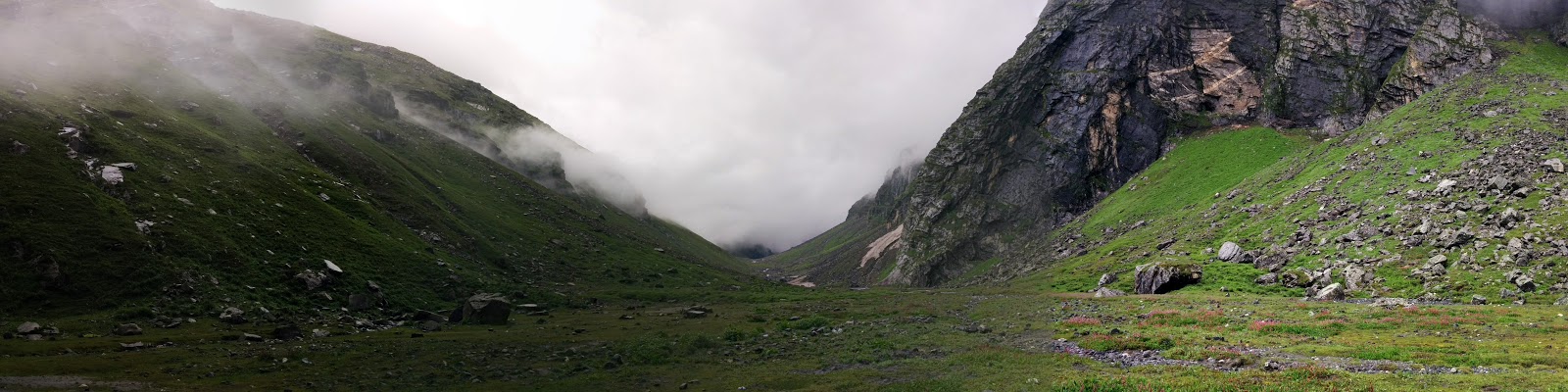
This day, we left the NIM campus for first camp in Tela. This day we started our journey by bus from NIM campus early morning after offering prayers in the temple of NIM campus to Bukki which is on the way to Gangotri. During this bus journey, we could witness the aftermath of previous year Uttarakhand disaster. It took around 2 hours to reach Bukki by bus.

From Bukki, we'll be trekking through Dingad Valley, named so after a glacial stream Dingad (gad=stream)  originating from Dokrani Bamak (bamak = glacier)  which is our training area. The stream originating from the glacier's melting water later joins many other snow / ice melted streams and finally merges into Bhagirathi river near Bukki village. Bukki village is 2 km from the bus terminus situated on the right bank of Bhagirathi river. On way to Dokriani glacier, one has to walk 23 km from the road (Bukki village). After crossing the Bhagirathi river a footpath flows along the steep mountain slopes up to Tela camp (2500 m), from Tela to Gujjar hut a 12 km run along the Dingad stream is a route offered to cross the several up and down ridges, many samll and big streams and dense mixed forests of deodar, rhododendron (burans), oak, pine etc. provide an atmosphere of perfect peace and tranquility. Gujjar Hut (a summer camp of Gujjars with their cattles) is located at a height of 3500 m, just 5 km below the Dokriani glacier. Gujjar Hut is the gateway of the valley.

The valley has a gentle slope with different land features formed by the glacier and surrounded by snow-covered peaks. This place is good for camping and one can walk up to the glacier and adjoining areas and climb the small peaks. Only Gujjar huts and a base camp (near the glacier snout) of Wadia Institute of Himalayan Geology, Dehradun lie on the way. The best season to visit is through out summer and autumn. Besides the above two glaciers, Kedar, Rudugaira and Jaonli are some other glaciers which are approachable by the same way.

We started our trek to Tela camping site (altitude 8200 ft. )from Bhuki around 10 AM.This trek is around 8 kms. This was decent trek through dense jungles and was not very tiring except the last few minutes which was long continuous ascent.  Daily treks to Tekhla had made us stronger. We reached Tel camp around 1:30 PM and after little cooling down stretching exercises we had our lunch prepared by NIM cooking staff. Later we pitched our tents and went for acclimatization walk to a nearby hill in the evening. It was a beautiful walk through jungle which has meadows and at the top there was beautiful view of surroundings. At Tel near our campsite there were few houses of Gujjars and they have cattles which were tied nearby. Here there is also a small tower installed by Wadia Institute, Dehradun for weather monitoring.

Day 10
This day we had this very long trek from Tel camp to Gujjar Hut (altitude 11200 ft.). It counts as toughest day so far. We started around 7:30 AM after cleaning Tel campsite and reached Gujjar Hut at 2:30 PM. From Gujjar hut, we started getting nice view of nearby peaks like Jaonli (6630 meters). The place Gujjar hut was given this name because of few huts of Gujjars nearby who stay here in summers. We went for our acclimatization walk to nearby lake Khera Tal (Serpent Lake) which is a small lake between a vast and very beautiful meadow. Vast ground surrounded by tall trees with an opens on one side for magnificent view of peaks Jaonli (6630 meters) and DKD-II (5670 meters). DKD-II is the peak which we hoped to climb as part of our height gain phase later in this course. Khera in local language means snake. There is a story about this lake and a snake living around it which was previously poisoning a nearby stream Hurra Nala (Nala = a stream )  and thereby causing deaths in the village which depended on it. There is also a temple nearby the lake. People of Bhuki village sometimes come here to offer prayers and stay here overnight. In Feb-April this whole area is covered with snow. We were told that in month of June, this valley is full of flowers and there are many butterflies around here.

Day 11
Base Camp
In morning at Gujjar Hut, we had a class of map reading and get to practice using GPS devices. Everybody was given three co-ordinates to point out on map and follow these points using GPS device. These points were on the way to NIM Base Camp (12300 ft.). Every rope moved ahead with their instructors to Base Camp with the routes set using three waypoints given. This trek is relatively small and is around 2.5 km. Treeline vanishes on the way and we could see only shrubs around there.
After reaching base camp, we pitched our tents and did some cleaning of the area, cut the grass etc. There was not much for the day.

Phase 2: Ice Craft

Day 12,13
From this day, our training of ice craft started. The Dokrani glacier is bit far from base camp. Seems
as if glacier has receded a lot. Groups barely found decent walls to practice. All of the ice was covered with moraine. We cleaned it up for practicing. Our instructor Subhash Sir found a decent wall to practice we practiced different climbing positions on ice and climbing using ice pitons etc.
In my opinion, NIM's ice craft area is much less in comparison of HMI. It may be the time, when NIM may have to shift the base camp further up to Advance Base Camp.

These two days. it was mostly revision of  ice craft taught in basic course. In the second half on the second day, we were involved in checking of tents, which we'll be carrying to advance base camp (ABC) be used in high altitude.

Day 14
Advance Base Camp
Today, we ferried load from base camp to advance base camp (13500 ft.). With fairly heavy load the trek was tiring and I was huffing and puffing on the way. It like the last flat piece of of very picturesque land in cirque ahead. The surroundings form an amphitheater of mountains which from north-east-south constitutes of Machha ki Dhar, Jaonli, Draupadi ka Daanda, Choro ki Dhar and Rakhua Top. We dumped all the load like food items, tents etc in a shelter made of rock and came back to the base camp. It felt like a long walk. Back in the base camp this day, we had a lecture on mountain terminology after lunch.


Day 15
We moved to ABC with our personal belongings. We were allowed to leave few of our things which we thought would not be required above in ABC and further.
Looking towards BC, from ABC
We reached ABC at 10:30 AM after leaving and wrapping up tents at base camp past 8 AM. After some stretching exercises, we started pitching our tents. We erected volleyball net and a stone shelter where kitchen staff could heat water for us. Everybody was entitled for one hot bottle of water every morning and evening for drinking purposes at base camp and advance base camp. It was a lot of fun playing volleyball at ABC in the surroundings it offer.
Dokrani glacier: Further ahead is our training area

Advance Ice Craft @ Dokrani Glacier
Day 16, 17
We started the day by marching up to upper part of Dokrani glacier. Most of the trek is on moraine and glacier.
Training area is not very far from the campsite and there are ample ice walls for all of us to practice. After demonstration of technique by our instructors, we practiced the same.
We learned few advanced ice climbing techniques. This includes two piton climbing, aid climbing on ice wall. In month of September, there wasn't much snow on these ice walls. Very soon gloves would get and dirty with fast melting ice and supra glacial moraine.


It was continuously hailing in the in the second half of the day. It started snowing heavily in the evening which lasted till late night.


Advance Ice craft Training


For the duration of our stay at base camp we took ropewise turns to prepare dinner our everybody, which was part of our training as told.

We also had a class on high altitude cooking with different kind of fuels and stoves.

Phase 3: Snow Craft

Day 18
Out tents in ABC in the morning after snow
Since our phases of rock and ice craft was over, it was turn of snow craft. In our time there wasn't much snow. It was decided to practice snow craft on thin layer of packed snow patch with elevation of arounf 60 to 70 on a ridge of Machha ki Dhar which had ice beneath. Few people including me found difficult to maintain balance and practice on this patch. I had a fall which I couldn't arrest with ice axe while practicing and twisted my ankle. It wasn't severe, but it got me limping. It snowed again later in the afternoon. This completes our training part.


Phase 4: Height Gain

Day 19
For our height gain we hoped to summit DKD-II if weather allowed. We were warned that if weather doesn't allow we may not be able to reach the summit and return halfway. Anyway at this we ferried load to our Camp 1 (15800 ft.) which was also our summit camp. Loads included high altitude tents butane gas cans, burners, technical gears and other eatables.  It was an arduous task to ascent on continuous ice and moraine. I had OTG (over the glass) snow goggles which were too foggy to see and made the trek difficult. I had to walk without snow goggles most of the time. After reaching there, we set up tents for kitchen and store room and dumped our loads. The camp 1 area is a cwm (pronounced coom). This is a relatively flat area completely on glacier and many crevasses around. We could see all kinds of features of ice which we were told around. Ice tables, serac, bergschrund, crevasses, overhanging glaciers. If we're facing towards east, we had DKD on our right, but summit wasn't visible from there. Jaonli was towards north or our left. Jaonli (6632 meters) seemed so close as if we could walk over the summit. But standard way to the Jaonli was from behind (relatively may be from north face). The glaciers from Jaonli and DKD meet here to form the Dokrani glacier (around 5 km long).
While returning from camp 1, weather got really bad. It was complete whiteout. We trekked back in continuous snowfall. Drenched in sweat from inside and wet from outside with snow and hail, we walked back to advance base camp. After seeing this weather I really saw the dwindling chance for the summit, as there was now a good chance that we may not be going for the summit. If the weather doesn't clear soon, our chance to summit DKD is going to be feeble. It snowed whole day. Windproofs were completely wet. I kept my half wet clothes etc in sleeping bag to keep them warm.

Day 20
We packed our bags early morning from ABC and did routine cleaning of tent area before leaving. We reached camp 1 around 10:30 AM and started pitching our tents on the glacier. There was some snow over the ice which we beat to make the area for tent flat. We were getting tired easily with heavy movement like lifting stones for preparing the camp and other staff tents, kitchen etc. We could hear the water flowing through the deep crevasses. There was hole dug in the ice which stored some melted water in the day which we used for cooking maggi for lunch and warming water. Each tent which accommodated some 5 people was given a butane stove for cooking. With tents facing to each other on the ice in a row, and everybody cooking outside; it looked like as if we've established a small market on the glacier. After this, few handpicked people (around 6 to 7) along with two instructors left for the recce and route opening for tomorrow's summit attempt. Following them, rest of us also left for making the moraine part of route a bit stable. We all made cairns and fixed loose rocks along the way in the evening. We were told that we'll have to wake up at 2 AM and leave for the summit attempt at 4 AM sharp. Anybody gets late will be left there only. It was freezing cold in the night inside the tent. There wasn't much space inside the tent and we kept our snow boots in the vestibule. Thinking of going to loo instilled fear. There wasn't much time to sleep. I was guessing the time between short naps. Our tent was continuously making flapping sounds in wind. In night we could hear continuous deep noises of glacier moving beneath us. I couldn't sleep in night. Sleeping bag got wet from one side.

Day 21
We woke up in hurry after 2 AM and prepared ourselves for summit attempt. Chilling wind was blowing as we equipped ourselves with the harness set and other technical gear. I kept the breakfast in the bag and left for the summit with everybody. It was dark and everybody was wearing torches over head. We started the ascent in the moraine spanning high up towards our way with the helps of cairns established last evening. Everybody was waling briskly as if there was a very narrow time window for the summit. We're told that if somebody gets too late he may have to return from there only. After completing the ascent on moraine we put on crampons to walk on the ice. It looked very beautiful to see these many people ascending through the icy ridge with head-torches in the night. Everybody was walking silently. The cold and the wind was making talking difficult. At dawn, we reached a relatively flat area full of snow from where we could the peak of DKD-II. Behind us we could see the peaks of Gangotri valley. It was a magnificent view with the rising sun.
Ahead of us ropes were being fixed by our ropemate Deepak Rana and our instructor Subhash Thakur. It was a steep climb with unfathomable snow. It was very difficult to walk on the steep ascent this much powdery snow.

We self anchored ourselves to the established fixed rope and started the ascent. Trying to move ahead one step was making slide down further. But somehow, I learned the trick to make proper steps and walk up. The sun was rising. There were few crevsses hidden in deep snow which opened up their faces with people moving over. Everybody was moving slow. At some point we had to go one by one. After more than an hour of steep climb on snow like quick sand I could see the last rope to the summit.
View from DKD-II

I reached there around 8:15 AM. Opening the route, Deepak and Subhash sir reached there around 7:45 am.We congratulated each other for our successfully summit. It was blissful moment. We could the surrounding peaks protruding upside from the quilt of clouds. Senior instructor Jagmohan Singh Rawat introduced us to the surrounding peaks. We could see Shrikanth, Bandarpoonch Range, Kala Nag, Rudragaira, G
angotri Range, Jaonli, Nanda Devi, Kedar Dome, Kedarnath Valley DKD-I. After that everybody got busy posing and clicking pictures. After some 15-20 mins, we started our descent. It was fairly difficult to descending in steps in such steep snow. When we climbed down the major part part, we were given few mins break for breakfast. There wasn't any break before that. Common equipments like ropes changed hands and we started climbing down with happiness on our faces. While we were climbing down we could see the basic course guys at our camp 1, who were there for there height gain phase. At cam 1, we were congratulated by the kitchen staff and Chief Instructor for our successful climb.  Everybody was completely exhausted after this arduous climb.After reaching I pulled out the packed breakfast and shared it with my ropemates. In our rope, I and one of my ropemate were little feverish and went back to sleep. Everybody was really happy that we'll  be going back to base camp tomorrow. Most of us were planning a grand party after this course.

Day 21
We wrapped up our camp 1 and cleaned up the tent area. Trekked back to base camp passing through advance base camp and depositing the technical and other stuff  issued for camp 1. At base camp, we were greeted by all the basic course instructors and basic course guys who were clapping for our us. They congratulated us for our successful summit. We pitched our tents at base camp and cleaned and dried wet equipments clothes etc.

Day 22
It was exam day. There were few objective and few short answer subjective questions. After that we were competing for our map reading exam. We're given 2 points to which we had to reach. We were mostly running as one point was at Gujjar Hut and second was little off on the way to ABC.

Day 23, 24
Trekking back first from BC to Tela and then Tela to Bhuki. We were all happy to see other people and civilization. A bus from NIM was waiting to take us to the institute. It was like 10 in the morning. Soon after reaching there most of us got busy with writing the expedition report which had to be submitted the next day. After bath and lunch in the institute we submitted our equipments. In evening, we were allowed to go to the market to get the expedition report printed.

Day 25 to end of course
We had graduation ceremony and there was a cultural event in which our course-mates   participated.