Saturday, October 15

Mountaineering Institutes in India

Although there are many other institutes in India, but these two are the most sought ones. IMF (Indian Mountaineering Foundation), which is apex national body in this field lists 5 institutes on it's webpage.


  1. Himalayan Mountaineering Institute (HMI), Darjeeling, West Bengal
  2. Nehru Institute Of Mountaineering (NIM), Uttarkashi, Uttarakhand
  3. Atal Bihari Vajpayee Institute of Mountaineering and Allied Sports (ABVMAS), Manali, Himachal Pradesh
  4. Jawahar Institute of Mountaineering (JIM), Pahalgam, Jammu & Kashmir
  5. Indian Institute of Skiing and Mountaineering, Gulmarg, Jammu & Kashmir
Other than these 5, there are few more institutes which conducts courses in mountaineering.

  1. Sonam Gyatso Mountaineering Institute (SGMI), Gangtok, Sikkim
  2. Nation Institute of Mountaineering and Allied Sports, Dirang, West Kameng, Arunachal Pradesh
  3. Pt. Nain Singh Rawat Mountaineering Institute, Munsiyari, Uttarakhand (Proposed)

Monday, July 18

Hampta Pass and Chandratal Trek Log

I was exploring some extended weekend treks as my office colleagues also wanted to come along on my next trek. After searching and negotiating a lot, no agreeable trek couldn't be decided and now that I have to travel solo, I finally decided to go for Hampta Pass and Chandratal.. Hampta pass trek starts from Manali, Himachal Pradesh. It is a small pass on Pir Panjal range of Himalayas, between Lahaul and Kullu valley in Himachal Pradesh. Vertical rock walls, water falls, hanging glaciers, tiny lakes, peaks rising above 6000 m are main characteristics of this trek. I was very excited about this trek because I was finally getting another chance to see Chandratal.


Kiran was also in town and ready for a weekend trek. We left Delhi on Thursday, 14 July so that we had an extra day before next week starts. Bus to Manali was running late and we reached there around 11A.M. After having heavy dinner around noon, we took a cab for Jobra. It takes an hour and forty hairpin bends to arrive at Jobra. It was around 2 PM when we reached there. We left immediately, as we had planned to reach Balu Ka Ghera on our first day of trek and it was already late. It had rained earlier in the day and path was slippery till Chika village.


In few hours of trek, crossing few streams we reached Jwara. Clouds were all around us and visibility was very poor.

Balu ka ghera was still like an hour far from Jwara. There wasn't much daylight left and it could rain anytime. We decided to pitch our tents in Jwara. In the backdrop, we had a vertical rocky cliff with a nice view of waterfall. There was a shop in Jwara from where we got ourselves nice dinner for the night.


Campsite at Jwara


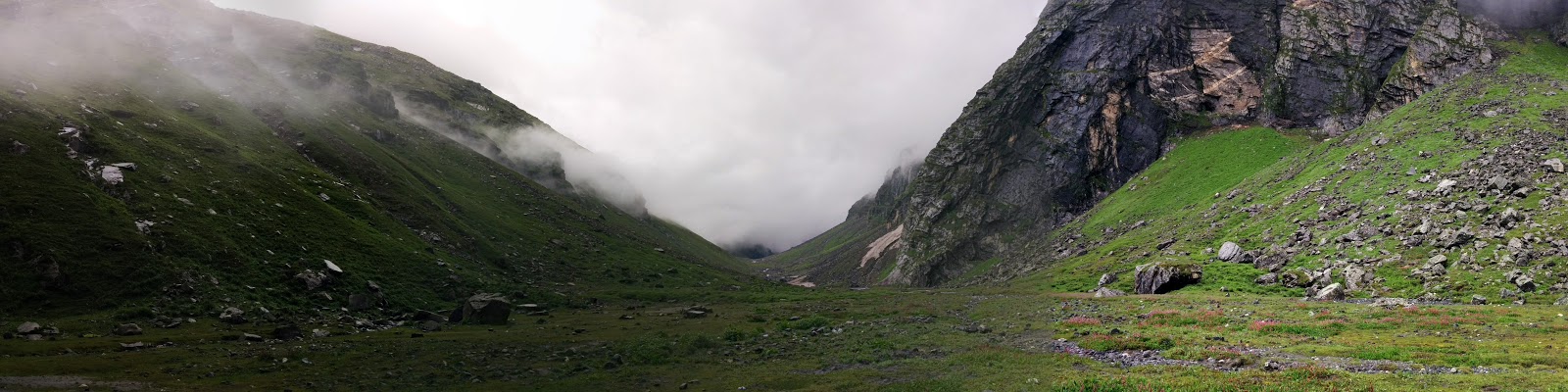
It was Saturday, June 16th. We started for Balu ka Ghera early morning next day. it was all misty from the beginning which was giving the whole valley a mystic look.

It started raining heavily when we reached Balu Ka Ghera. We got 4 parathas packed from there to have lunch later in the day. After more than an hour wait in Balu Ka Ghera, when the rain didn't stop; we prepared ourselves to walk in rain.

There was a Dutch couple, whom we had met in Jwara. They also arrived Balu Ka Ghera when we were about to leave. We started from Balu Ka Ghera together. They were thinking of returning back from the pass but we had plans to go further. Before the ascent to pass starts, there is a big lake where we bid them goodbye and continued our journey.
Small lake on the way up to pass

In heavy rain, the stream beside us was ferocious which actually accompanied us all along the trek in the valley. After crossing the some boulders, we reached the glacier. In such low visibility, it was getting difficult to find our way forward. Kiran was incessantly asking whether we are on the right path or not. I followed the tracks of mules on the glacier and reached the plateau. It was real cloudy and it seemed that I had lost my way here. We had a pack biscuit there and decided to look closely for tracks. It seemed, that we had to go back and follow the track more closely. On our left was a vertical rocky cliff.
The valley, clouds ahead on the pass

It was there when I heard some sound of mules walking somewhere nearby. I rushed towards the noise, though between so dense clouds, it was being difficult to figure out. Following the mule sound, I heard voice of a man controlling the mules. We shouted and asked whether anybody is there. The mules were gone and lost in the clouds by then. After few minutes, someone replied to our hello. When we rushed towards the sound, it was the same dutch couple with their guide. The lady told me, that they decided to cross the pass same day. The lady was was kind enough to offer us chocolates. We were just few meters away from the trail, but without their help we definitely would've gone in the wrong direction. This could've lost us at least few precious hours. We were actually few meters away from the trail. It's just that the trail makes an unusual bend towards left while going up at the highest point of trek which we would have easily figured out in clearer sky.

Towards Shiagoru From Hampta Pass
With them, we started our descent to Shiagoru. It's a steep descent which was little slippery due to rains. The rain was little slow at this part of valley (Lahaul). If it was a normal day, we could've had a nice view of Indrasan peak which was right to us while climbing down. We were descending to Lahaul Valley. The arrangements were already there for the night in Shiagoru for the Dutch couple. We decided to trek further down to Chhatru. Kiran had to go back next day for Delhi on Sunday to join office. The stream in Shiagoru had grown strong due to continuous rain that day. It's a flat area fed from glacier; it wasn't deep but certainly was cold. Having crossed the stream with our hands joined, we took off for Chhatru. From Shiagoru to Chhatru, it's a long walk but easy descent. The sun was about to set when we reached Chhatru roadhead. Chhatru is on the way to Kaza from Manali. We pitched our tents, and were invited for dinner by trek organizers from Bikat adventures who were also camped there.
Before Chhatru


Early morning, we had a quick breakfast in Chhatru. There were few truck drivers having tea. When they were about to leave, I asked them for a drop to Batal. I started my journey ahead with them after saying goodbye to Kiran who was waiting for a conveyance that he can get to Manali. Chhatru to Batal isn't very far, but due to road conditions it was already afternoon when I reached Batal. After having lunch in Batal, I enquired for the directions to Chandratal. People suggested me to go to Kunzum pass and start a near downhill trek from there. I took there advice, as it was clear that the road from Batal to Chandratal was only preferred for vehicles. Those truck drivers were still there having lunch. I joined them again when they left for Kaza.

It was raining in Kunzum la, when I reached there. There was no one who could tell me the way to Chandratal, though there was a board with signboard of Chandratal. I just decided to follow the path behind the board. It was well laid trail till I reached a point from where I had a view of valley. At this point the trail ended and I had nowhere to go. I could see tents far in the valley, but there was a very steep descent. I tried to go down that path, but had to to turn back as it was very slippery. When many attempts to find a better way to the valley failed I had to retrace the path back so as to find some alternative way. I was sure that I was on right path to Chandratal. After few meters of travelling back, there was a trail sharp left climbing towards the nearby hill. I took that and climbed the hill to see around. From there, I could see the trail going further inside the valley. Thanking god, I trotted down the trail. All along the way, the weather was clear and I had a nice view of valley and Chandra river valley.
Chandra Valley

Finally, the Chandratal was in sight. I aimed to reach Chandratal with some buffer time to explore. It was not allowed to camp there but there were many people camping around Chandratal. There was no authority to control this. While trekking from Kunjum La to Chandratal, I did not find any kiosk or office where one could find any kind camping permits etc. The visitors of Chandratal, mostly were with some trek organization on four wheelers with exceptions of few bikers.

Chandra Taal

Despite that, Chandratal was still very beautiful, clean and peaceful. The small stream emanating from Chandratal and a wooden bridge looks like a setting from a fairy tale. I sat there around half an hour. When sun had set, I turned back towards Batal road looking for a place to camp. Most of the good places nearby were completely occupied by private organizations which was little disheartening. Anyhow I was able to find a place to camp besides some Paragon camping site. Next day returned back to Batal. On the way to Batal from Chandratal, I was offered a lift by a jeep accompanying bikers. In Batal, I was able get hold of a jeep going towards Manali. Buses are not very reliable on this route. The driver of the jeep was in his teens and he was determined to reach Manali by lunch time. By afternoon, I was in Manali where I had lunch and explored the market until it was time for bus to Delhi.


Monday, June 6

Indrahar Pass Trek Log

In our previous treks we had been travelling light and walking long miles a day thus helping us do treks with less leaves from work. Planning first trek of 2016, I was thinking of something in Himachal Pradesh and then I got my hands on Depi Chaudhary's Himalaya trek maps. It's very detailed one and I spent hours studying it. Hoping to combine two short duration treks, I thought of Indrahar pass(4350 m) in Dhauladhar Range between Kangra and Chamba valleys, and Kugti Pass (5050m) in Chamba. Indrahar pass is popular among trekkers but Kugti pass is less travelled with altitude of significant 5000+ meters and this required some travelling on road as well.


Alternatively, I also thought of doing Minkiani pass from Laka cave after coming down from Indrahar pass. Depi Chaudhary's map was showing a route to Minkiani pass from Laka cave which is little beyond Snow point cafe but we zeroed down on Indrahar pass.

My always ready travel buddies Kiran and Akshay were willing to join for this trek though Akshay wasn't much updated on the diversions which I and Kiran were planning to take.


With thought to first reach Indrahar pass and later decide what next, we left on Thursday, 12th May. Akshay wanted to see Bhagsu waterfall, so we started our day with that. We were told about a path leading to Triund via Upper Bhagsu village. There was a small puddle where it used to be a pond. We started for Triund around 12. It was a steep climb till we merged into Triund trek route. It was a hot day and there weren't enough trees for shade. We had our lunch in Triund and soon decided to leave for Snowline Cafe.


Akshay was little reluctant to walk that day and I was slowly giving up hope to reach Lahesh cave the same day. I sincerely wished that we reach Lahesh cave on the same day after halting for a while at Snowline cafe for food but by the time everybody reached Snowline, we decided to camp there and leave for Indrahar pass early next morning. We all were carrying our separate tents but the night got very windy and Kiran had to sleep in Akshay's tent as his tent fell due to wind.

In the night we were informed of snow conditions on the trail and were advised to take a guide. We were told that an ice axe might be needed to carve out steps in a glacier which falls very steep from peak. There was small group of people who attempted to reach Indrahar pass a day before with a guide but they had to come back from few 100 meters before pass due to snow condition and weather. Though, short on money we couldn't have been able to afford guide that day and we started little late around 8:30 AM on Friday contrary to what we had planned. There were two more people leaving that day from Snowline Cafe for the pass. They even had an ice axe and were even planning to cross the pass that day. One of them was Ken from Japan. I was hopeful that if we followed them, we would be able to get to the top. They left before us. Akshay was not willing to continue, though he came along us for a stroll till Laka Cave area. Negotiating the Laka glacier took a little time and Akshay didn't want to continue, so he decided to walk back from there.
it look a little time .. though it was fun

waterfall near lahesh cave

We followed the trail and cairns on the way. The path was not very clear, sometimes I had to look around to be sure that we are on the right track. We continued our walk but Ken and his friend were nowhere to be seen by now. There were steps carved in glacier. Kiran hesitantly crossed it.

Slowly and steadily, we were making progress. I was finding it difficult to follow the track, though I was sure that it was the right path.


The top seemed very close. I saw a severed head of what looked like a goat and blood patches on the trek. I couldn't think of any reason of  what killed it that way. Kiran was uneasy after seeing that and was feeling tired so he asked me go ahead without him. It was past noon.
Weather seemed to coming in heavily. Suddenly it was all dark and cloudy. It was difficult to see what lies ahead. Kiran was far behind and I was not able to find trail further. Markers were pointing towards a glacier which was very steep. It wasn't very wide but there were no footsteps. Suddenly it started to hail. and I feared of it getting worse as there was no place for me to hide so I decided to turn back and be content with the progress made on the trek.


With time, the hailing slowed down but there wasn't much time to change the decision for that day. Few hours after we reached Snowline Cafe, Ken and his friends also came back and they managed to reach the top. I sat there and pondered what went wrong. Why did I turn back when I knew there wasn't much left till the top, I was almost there. While talking to the cafe owner, he suggested that had we started little early, we could've got company of local Gaddi people, who crossed that pass frequently with their goats and sheeps.


At center is the severed head of goat
Recollecting all what I have seen on the way, I asked the shop owner at cafe about the severed head of goat. He told me that Gaddi's kill the goat which walk slowly because if they are left behind, these goats may die with hunger.


We returned back from Snowline next day on Saturday to McLeodganj. Here is our shared photo album.


Next Attempt:

It had been two weeks since my last unsuccessful attempt to complete the trek, the thought of not able to complete that trek was constantly bothering me. With a constant feeling of " I shouldn't have given up so easily ", I knew I won't be able to plan any other trek unless I complete this one so I decided to make another attempt to reach the top atleast. It was Friday, 3rd of June when I left alone for McLeodganj. My only camera; my mobile gave in due to charging problems. I didn't even carry my tent this time and decided to stay in caves only. There was another cave on the other side near Chatta where I would be staying, if I were to cross the pass.

With all the thoughts and will, I started off for Lahesh cave on Saturday Morning. Rested for a while at snowline cafe, I left for Lahesh cave after having lunch. I was in luck as there few gaddis who were to cross that pass tomorrow. Next morning, I heard calls of those shepherds while I was getting ready and I tagged along with them. Those sheeps were really slow while walking. I was following them and sometimes tried to help them controlling the sheeps. When I reached the point from where I turned back last time; I had to go ahead of these sheeps as they were nearly came to a halt. Few local people were coming down from the top where they had gone to offer prayers. They also offered me prasad. Walking further more for around half an hour I was at the top. The lead shepherd was sitting there and enjoying the view of Chamba valley. Breathing lively and cherishing what beautiful the view was, there is another thought going in back of my mind and I was wondering what would be the view of the other side from the top. Heavenly it was, much more than what I imagined. The steep descent from pass goes to a vast flat plateau covered with snow. From there one can see Pir panjal range and Mani Mahesh peak. Few minutes later another group joined us. We all stayed around for an hour and roamed around to see the view of valley from different spots. After an hour, clouds started rising from the valley and with rising clouds, we too started back. And in a short while, it started hailing and raining heavily. We continued our descent slowly and cautiously as the path was now slippery due to rain. And then we heard the sound of loud thunder and saw frequent lighting around. It continued all along the way and rain got heavier.We had to take shelter and Lahesh cave was nearest to our rescue. After an hour it stopped raining and we again started walking down to Snowline cafe. I was having lunch over there when it started raining again, actually this time it was pouring. When it slowed down, I too started my journey back slowly towards Mcleodganj. It was already dark when I reached the town and I had to no other option than to stay over night in Mcleodganj due to non-availability of bus. I was happy that I reached the pass which gave me many sleepless nights because I left it incomplete last time. I still wished to cross the pass to see what lies on the other side; but I was travelling too light for that.

Wednesday, December 30

Har ki Doon Trek Log

Less than a week was left of year 2015 and holidays were lined up. In search of a winter trek, I had Kauri pass and Har ki doon in my mind. A month ago Kiran and I had just been to to Hemkund Sahib and Valley of Flowers. Dalima was also willing to join us in our next trek. She needed an esacape from busy city life. Har ki doon is well known most one of most popular winter treks in Uttarkashi region. During same time YHAI had been taking many batches for Kedarkantha trek. Trek to Kedarkantha also stars from Sankri, Uttarakhand.

We started on Saturday night, 26 Dec for Dehradun. We couldn't find any any conveyance for Sankri from there so we moved to Rishikesh. We took a bus around 5 AM for Sankri. It was long ride of around 11 hours. Sun was about to set when we reached Sankri. It is a small and quiet place and accommodations were already full of trekkers in this season. After some search we were able to find a place to stay. Nearby, there was a small shop where we had dinner and chit chat with other trekker who were staying nearby. After some last time purchase, we also arranged for a jeep to Taluka from where we were to start our trek.

It was around 8 AM, when we reached Taluka. It was a cold morning. We started off after some light breakfast. Most of the trails goes along the river Rupin. The gentle sound of river all along the first day trek is very comforting and refreshing. The trail is also very beautiful. River is very approachable from most of the first day trail.


It was around 4 PM when we reached Osla village. It was a steep climb after crossing the bridge. The village was very picturesque. From the river bed it seems as if people have made nests in the mountains. All houses of same color and made of wood which mixes with background.

We haven't had anything to eat till now. Dalima's knee was giving her a tough time. Children of the village flocked around us asking different questions. I got some maggi and biscuits from a shop in the village. the local people seemed very helpful and nice. A man from village offered to prepare it for us while we talked to the children. There aren't many men in the village. Those with whom I talked, were very keen on having us as their guest. We had tents but we did need food. We decided to have dinner with the old man who prepared maggi for us and pitched our tent outside his home. There was another family insisting to stay in their home. It was cold out there and Dalima stayed with them. It was very peculiar to see how these houses are made of wood and housed a hearth made of mud in the room. Just above the hearth roof open to make room for smoke. There is a place to store wood and hay below the house. Dalima's knee problem had aggravated and she decided to take some rest next day. The house owner was happy to have her as guest. Children were very curious excited around her and constantly chatting.  We enquired about the logistics which we need to take and arrangements for food during the rest of the trek. We promised Dalima to be back as soon as we can.


On tuesday, We started off early in the morning and wrapping up our tents. Crossing Kalkatiyadhar campsite, we reached Har ki doon in afternoon.

It was a sunny day and there weren't much trees on the trail. The trail just before the Har ki doon was enchanting and covered with snow with beautiful little streams joining Tons river and trees around. Har ki doon valley is a big amphitheatre which lies in the valley of majestic Swargarohini peak. It is an inexplicable experience to see such a close view of Swargarohini peak. This trail is believed to be taken by Pandavas who attempted to go to heaven with their bodies. Kiran had some phaphda which we had with pickles. We took water and essential stuff in our daypack and went exploring towards Juandhar glacier in the valley. I couldn't take my eyes off from the Swargarohini peak and was immersed in the thoughts of how Pandavas who attempted to climb the peak in Mahabharata era. The first ascent of Swargarohini was done by team of NIM(Nehru Institute Of Mountaineering) instructors in 1990, Uttarkashi from where I once did my AMC.

We walked inside the valley until sun started to set.


We had to come back to pitch our tent to make arrangements of dinner and pitch our tents. We pitched our tents beside the forest rest house there and requested for dinner to the caretaker of the rest house. We watched the setting sun sitting on the big boulder near campsite. It was very cold and windy in the night. We spent most of the time in the kitchen before going to sleep. We talked about what lies further on the trail and treks in the area. I promised myself to cross the Borasu pass next time which lies further on the trail and take a diversion to Ruinsaira tal which is around 14 km from Osla village.


It was already 7 when we woke up next morning. We wrapped our tents and left at once after having tea. We started our retreat around 8. It was an easy descent and we walked on scout's pace. Dalima was eagerly waiting for us in the village where we had lunch around 11. After paying all the dues, we left for Taluka around 12. It was not long when we reached Taluka.

We still had two spare days left and we could've attempted for Kedarkantha trek as well. New year parties with friends in Delhi are also cool; we thought and left for Delhi next morning.

Here is the link to our shared album. 

Wednesday, November 18

Valley of Flowers and Hemkund Sahib Trek Log

Having completed a quick trek to Roopkund in Dussehara vacations, I hoped to do another in Deepawali. I had no plans of going home from Noida in vacations. Kiran was also in Gurgaon itself. This time if we took one day leave from office, we could have 5 days to do something. I proposed going to Joshimath and doing some of treks among Kauri Pass(Curzon Trail), Hemkund Sahib and Valley Of flowers over there. Though Valley of flowers and Hemkund Sahib were already closed by then for the winter season. Since we were only two, we decided to minimize the expense using bus travel instead cab.

There were very few buses on the route due to Deepawali that day.  We managed our way to Joshimath by changing buses and eventually booking a cab from Karnaprayag. It was night when we arrived Joshimath. To start trekking for Valley Of Flowers & Hemkund Sahib early morning, it would have been better if we stayed in Govind ghat that night. The cab driver was asking for a lot for Govind ghat so we had to stay in Joshimath and went to Govind ghat next morning.

Trail

After asking about the route, we left Govind ghat around 8 in morning. Govind ghat is situated at the confluence of rivers Alaknanda and Lakshman Ganga. The route going through Bhyundar valley is well paved and goes through a dense forest with Bhyundar Ganga on the right side. After 3-4 hours walk we reached Bhyundar village.


Along Bhyundar village to Ghangharia


There was no one in the village except one shop and 3-4 labours working on a home. Having our lunch we enquired upon further trail ahead. The shopkeeper told us that there is absolutely no one beyond this point in Ghangharia or Hemkund Sahib and everything is closed. He also warned us about the bears and leopards in the area and gave us 2 crackers and some kerosene to light up fire in night.
After getting few chapatis packed with pickle, soon we left for Ghangharia. On our way, two dogs tagged along us after getting lured by Kiran with biscuits.


Hathi Parbat as seen from Bhyundar Village,
A trail to Kakbhushundi lake starts from here towards this mountain


Walking through the dense forest, it was past 2 P.M. when we reached Ghangharia.
This is a significant place along this trek with lots of houses along the both sides of street; but everything was closed. It gave the whole place an eerie appearance. After hiding our bags in the gallery of a rest house, we left for Valley of Flowers.


Towards Valley Of Flowers From Ghangharia,
The Pushpawati river gorge

The trek goes through the dense forest on left side and Pushpawati river gorge on the right. The Pushpawati river joins Bhuyandar Ganga near Ghangharia to form Lakshman Ganga.


The dogs chased grey langurs herds whenever they see them. Climbing our way after crossing Pushpawati river, and walking through the dense forests with some snow along the trail; we reached Valley of Flowers.


Valley of Flowers in mid November

The flora in the valley was completely dried except few green patches here and there. We roamed inside the valley enjoying the view and clicking pictures.


After some walk inside the valley, we rested near the grave of Joan Margaret Legge (1885 - 1939) who died while collecting samples here. The sun was about to set, so we turned back towards Ghangharia. It was completely dark when we reached there.


We picked some woods from the street and lit up a fire with the help of kerosene. Sitting there, the dogs occasionally barked and ran along the street. Kiran feared that something is around and tried to look towards the way these dogs ran with torch. We only had 6 chapatis to eat. I suggested to eat next morning for breakfast as we needed enough energy to climb Hemkund Sahib. Kiran agreed to it and suggested to share our chapatis with the dogs dutifully protecting us in the night. After few hours of warming ourselves with fire, we decided to get some sleep. I kept the fire burning and pitched our tents in the gallery of the rest house. Dogs kept barking and running all night.

The footsteps
After sharing our breakfast with dogs, we started for Hemkund Sahib. It is a continuous 6 km climb till the top. After 3 kms, treeline ends and the path was snowy. The bridge on the way was disassembled so we found an alternate route nearby to go further. After the bridge there are stairs and there also is an alternate way. The stairs were steep and completely covered with snow but the alternate path is longer and not so steep. There was snow everywhere. After crossing the nullah, when I started on the stairs, I noticed foot steps of some big animal which walked before us on that path. Kiran found the path slippery and decided to take the alternate route. I climbed the stairs cautiously, wondering if some bear is waiting for me above. Later, I was assured that this could not be the case as the dogs went ahead and waited for me at the end of stairs. Kiran continued negotiating the snow, while I reached the gurudwara. After few mins, Kiran reached there and meanwhile I roamed around the serene Homkund lake taking pictures with my mobile which still retained it's juice in airplane mode. With the gentle breeze, the crystal clear rippling water of the lake was making sounds. We sat there on a stone by the lake for few minutes and watched around. The dogs were lying on the snow basking in the sun. Kiran wondered if they were very tired and are sleeping.

The Homkund Lake

Around 11 AM, started trekking back for Govind ghat. It was a long way ahead and we both were hungry. We picked our bags up from Ghangharia from where we stayed last night and continued the descent. We talked about having big lunch at Bhyundar. The shopkeeper was waiting for us; when we we reached there in noon. After lunch and little rest in Bhyundar, we returned the kerosene and the crackers which we didn't use. It was necessary to reach Govind Ghat by evening, if we wanted to have dinner and stay in Joshimath. Around 6 PM, when we reached Govind Ghat it was dark. With some luck, we managed to catch a jeep coming from Badrinath.

We still had a day left after these two trek days. Kauri pass was at least 28 km one way which I didn't think could be managed in the remaining time. Next day we ended our trip after visiting Badrinath temple and stayed overnight in Joshimath.


Tuesday, November 17

Roopkund Trek Log

One of my friend asked me if I had any plans for Dussehara vacations. For one day leave, we were getting 4 days in our hand. He was planning for Roopkund trek as much as it can be done in two days which we would left with after taking out the travel time from Delhi. A day before, he got little sick and there were three of us for the trek. Kiran was from Bombay and Silva was from Brazil. We hadn't met before. Kiran was full of enthusiasm and wanted to complete this trek at any cost. I was supportive of this opinion and we chalked out our trek plan to make it possible. Silva had done a trek to Tungnath with Kiran and my friend Akshay few week back.

We left on Wednesday evening; the cab picked me up around 10:30 in night. After a whole night and day drive, next day we reached village Wan around 5 p.m. To make most of our lost time, we needed to cover some of trek that day. In few minutes, after arranging for our driver's accomodation; we left for the trek. We did get few advices for not leaving for trek at such time, but we went on.


Out morales were pretty boost up. Calling ourselves bad mofos; we went past the wan village down to the bridge on river Neelganga. By then it was completely dark. Holding our torches, we started to climb. Our aim was to reach Bedini around 11 in night. Even though, we were advised against it in the village, we thought that it is better to utilize this time in trek than to stay. It was around 10 p.m.; when we reached first camping site Gharoli Patal. Bedini was still 3 km. We had still enough juice left to reach Bedini that night. But after staying few mins for tea there; we decided to camp there only. It was very cold and windy.


A view from Bedini Bugyal
Next morning around 6, we left for Bhojbasa after having maggi for breakfast. We were happy that stopping at Gharoli Patal, previous night didn't cost us much time when we reached Bedini. After half an hour of admiring the beauty of vast meadows, and few clicks; we left for our next stop.


On the way to Patharnachuni
It was around 2 PM when we reached Patharnachuni where we had our lunch. Soon after, we left for our final stop, Bhojbasa. One the steep ascent to Kalu Vinayak, Silva was walking a bit slow. After few wait and move ahead; Kiran and me discussed if he could walk with Silva and I'll come back to carry the bag from Bhojbasa. I tried walking fast and reached Bojbasa early where I left the bag and rushed back towards Kalu Vinayak. Kiran and Silva were resting at Kalu Vinayak, which they had already climbed. Silva was feeling better now and didn't let me carry his bag. We came back from Kalu Vinayak together.


We all managed to reach Bhojbasa well before evening. Silva was having some headaches, I suggested him to have more tea and drink as much water as he can. We did a little walk around the campsite for acclimatization and had tea. We pitched our tents inside the forest hut. Although a lot colder, it was less windy than Bedini here.


Beyond Junargali
Next morning after having tea, we left for Roopkund around 6. We packed our tents and left our bag there in the hut. It was very cold and windy on the way. Some ice started to appear inside water bottle. After one and a half hour walk, we reached Roopkund. Silva was little behind. It was his first experince of such altitude and cold. There was some firewood left from previous fire; which I lit and warmed ourselves while waiting for Silva. Some dry sticks dry grass was around which I collected. When Silva was about to reach Roopkund; we left for Junargali. After few minutes of climb, we reached Junargali. Silva still was behind Roopkund. He would stop after few steps to catch a breath. It was windy was clear in Junargali with magnificent view of Mt. Trisul(7120m) and Nandaghunti(6309m).

Jorawar Gali Pass
A thought came to my mind for going ahead from there to Homkund. The door like structure with bell hanging by it looked very inviting. We didn't have that much time. We needed to move back as soon as we can if wanted to make it back to Wan village by night. After few minutes, Silva was in Roopkund. I asked Silva if really wanted to climb up to Junargali to which he said Yes. We waited for him there. Collecting litter there left by previous trekkers, we waited there on the stairs towards Shila Samudra.

After about an hour or so stay at Junargali, we started our way back to Bhojbasa. It was already 12 when we left there. After some tea and noodles, we left Bhojbasa around noon. There was another group of three people who was also on had similar plans as us. There also wanted to go back to Wan on that day itself. I was planning to go via Ali Bugyal; but it seemed, that it was too late for that. When we reached Pattahrnachuni in an hour or so, Silva was walking good. We decied against taking Ali Bugyal route, we needed at least 2-3 more hours than our usual. It was now sunset time when we reached Gharoli Patal. After taking a lot of shortcuts on descents; my legs were tired. I was exhausted and had very less control on my legs. It was now dark when I reached Neelganga bridge. I was out of water and thirsty till that time. I waited with other group for Kiran and Silva. After few mins they arrived. Silva had got blisters in his foot. We started our last patch of trek to Wan village. When we reached the village from Neelganga bridge, it seemed that we lost our way which we took before. After asking for directions and wasting around 2 hours, we managed to reach roadside around 9:30 p.m. where our cab driver was waiting for us.

We took little more than two trek days for this trek from Wan village to Roopkund. In retrospect, I think that if we had one more day, one day stay at Ali Bugyal would have been perfect finishing of the trek while coming back.

Wednesday, October 22

HMI, Darjeeling vs. NIM, Uttarkashi

This is one of those questions which comes to mind when going for a mountaineering course in India.
Having done my BMC from HMI and AMC from NIM, I got some idea about the training in these two institutes. Here is what I thought of HMI and NIM in terms of :

  • Organization
Both HMI and NIM are run by Ministry of Defence, GOI in collaboration with respective state governments. So, in terms and objective and philosophy and in training programs both are same. In my personal opinion, the past principals and the present principal (Col. Ajay Kothiyal) of NIM  seem more active and devoted to the institute. NIM played major role in rescue and rehabilitation work in the time 2013 Uttarakhand disaster. This was also widely covered in media.
  • Rock Climbing area
The biggest asset of NIM is that it has a vast rock climbing area in Tekhla. In this area, there are variety of rock features of varying degree of difficulty. Trainees have plenty of time to practice rock climbing techniques on these features. In HMI, there weren't much rock faces to climb. For rock climbing, it has Tenzing Rock and Gombu Rock in the outskirts of Darjeeling. They try to compensate this later in the course with the big boulders available around the base camp. So rest of the training in rock craft happens in Base camp area of HMI which is in Chaurikhang, Sikkim.

HMI's artificial wall seem definitely bigger than those in NIM and everything else is more or less same. Maybe because HMI installed these walls after NIM.
  • Glacier for training of ice climbing techniques
The Rathong glacier, training area of HMI has lot more ice walls to practice than the Dokrani glacier of NIM. Both the glaciers are receding very fast and trainees need to walk to the training area everyday which takes some time and energy. Dokrani glacier of NIM, has lot of moraine covering the ice walls and around the snout of the glacier where most of the training happens there isn't much blue ice. I saw plenty of smoking blue ice in Rathong glacier. It has big fields of blue ice around the training area. Although advance courses in NIM goes to a different training area upwards in the glacier for 2 days for their advance ice craft which has sufficient ice walls and relatively cleaner ice. Overall, in terms of ice walls available on which we get to train, HMI has lot better than NIM. Maybe in future, NIM may think of to change the base camp to get better area for ice craft. It would be more appropriate for NIM, to move the base camp to the place where they have their advance base camp.

  • Technical Equipments and Training
It was unanimously established among my course-mates of AMC who did their BMC from HMI that NIM provides more and advance technical equipments than HMI. In case of HMI advance techniques or use of advance equipments are mostly demonstrated by instructors but in NIM you'll get a chance to practice with/on them.
  • Trek to Base Camp
It is a fact that, to reach the base camp; the trek in HMI is tougher than that in NIM. In both institutes, it takes 3 days to reach base camp. The trek in HMI goes on relatively higher altitude than NIM and are longer on everyday. Situated on higher altitude than NIM, the base camp of HMI offers more splendid view of surrounding peaks.
  • Accomodation
The hostel of HMI and NIM are both well maintained and have all the required facilities. If you are pursuing basic course, you get to stay in barrack made of metal sheets and wood in HMI. It's all tent in NIM for both basic and advance courses outside the campus.
  • Location of Institute
In my opinion, roaming in and around Darjeeling has better experience than Uttarkashi. So, location wise, HMI wins and it also has bigger area with a zoo in it's campus.